Map Scale - Map Distance Measurement
Naturally it is impossible for real world features to be drawn on the map as large as their true size. Therefore in order to represent the real world, maps are made to a specific scale. Map scale is defined as the ratio of the distance between two points on the map to the corresponding distance on the ground. Maps come in a variety of scales. Large scale maps cover a small area with great detail and accuracy, while small scale maps cover a large area in less detail.
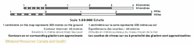
As shown in this image, map scales can be expressed as a verbal statement, as a fraction or ratio and finally as a graphic or bar scale. Such scale expressions can be used to find the ground distance between any features from conversion of the corresponding map distance measurement.
Verbal Scale:
"1 centimetre on the map represents 500m on the ground" is a verbal scale. Clearly here a distance of 1cm on the map corresponds to 500m on the earth's surface. So if you plan a route with a total distance of 22cm on the map, that would imply that you'll be traveling (22cm x 500m) / 1cm = 11000m or 11km on the ground.
Representative Fraction (RF) - Fractional Scale - Ratio Scale:
1:50000 represents the map scale as a mathematical ratio or fraction, thus the name ratio scale or fractional scale. 1:50000 can be shown as 1/50000 as well. Here such a scale means that one unit of measurment on the map is equal to 50000 of the same unit on the ground. Such a unit can be anything such as centimetre, meter, feet, inches, your finger length, half a lenght of a pencil, etc. Also we can say that any distance on the map is 1/50000 of its true value on the ground. Therefore 1cm on the map is equal to 50000cm on the ground, that is 1cm on the map is equal to (50000cm x 1m) /100cm = 500m or 0.5km on the ground. Again a 22cm route on the map can be calculated to be equal 22 x 50000cm = 1100000cm on the ground or (1100000cm x 1m) / 100cm = 11000m.
Bar Scale - Graphic Scale - Linear Scale:
Bar scale also known as scale bar, linear scale or graphical scale visually shows the relationship between distances on the map and the real world.

Usually more than one bar scale is shown on the side of the map, each using a different unit of measurement. To measure distance on web maps such Google Maps and OpenStreetMap, you can use the bar scale found on the corner of the map. The scale length and numbers get adjusted as the map is zoomed in or out. To see an example of measuring distances using bar scale, check the slope calculation from contour lines section.
Knowing the the fractional scale of a map, an engineer's or architect's scale ruler can be used to find the ground distances directly without the above mathematical calculations. The rulers can be found in both metric and English units of measurment. Many compasses have a similar scale ruler on their base plate. Finding distances of meandering features such as trails or rivers can be challenging and time consuming using a straight-edged object such as a ruler; in such cases you can use a string and place it on the map along the length of the feature, then place the string beside the bar scale for a direct measurement (or measure the lenght of it with a ruler).
Small Scale vs. Large Scale Maps
As mentioned above, maps come in variety of scales. Large or small scale maps can be distinguished by the use of fractional or ratio expressions. A map covering a large area (e.g. country or state) with a small scale fraction is a small scale map (e.g. 1:1000000), whereas a map covering a smaller area (town) with a large scale fraction is a large scale map (e.g. 1:10000). Most times the comparison of large scale and small scale maps can be relative. For example a 1:250000 map is smaller scale than a 1:50000 map. When confused, just carry out the division: 1/250000 < 1/50000; larger denominator results in a smaller number. The smaller scale the topo map is, there will be less detail with more generalization, and the harder it will be to detect terrain features. Therefore a map at a scale of 1:250000 while adequate for bike touring and car camping will not be useful for hiking or mountaineering trip planning.
When dealing with digital maps, it is normal for the map to be resized during printing in order for it to fit the page. A digital map's size might also get altered by saving it to another format (e.g. jpg, png, pdf). The same problem applies when a hard copy map is reproduced by photocopying. Note that in such situations the original ratio scale (or verbal scale) of the map would not be accurate anymore. However the advantage of bar scale is that it would shrink or expand consistently with the map in case of any resizing, and therefore will remain an accurate representation of the map scale. Also differing monitor resolutions and zoom levels make ratio/verbal scales for digital maps unreliable.
Another point worth considering is that while you can view a digital map at any scale by zooming in/out on the computer screen, you should note that when a map is produced at a certain scale with a certain level of accuracy (or level of error), changing its scale would not affect the original level of accuracy. For example when zooming in a 1:50000 topographic map so that its scale changes to 1:25000 or 1:10000, the level of accuracy of the map will remain at the original level designed for the 1:50000 map. In other words, your zoomed in map (to 1:10000 scale) would not possess the same level of accuracy as an originally published 1:10000 map.